 Atlases – the largest
part of the site. The works presented are more than 75 years old, and out of
copyright. Mostly, complete sets of plates from atlases are presented.
Atlases – the largest
part of the site. The works presented are more than 75 years old, and out of
copyright. Mostly, complete sets of plates from atlases are presented.
You can find an atlas either from the main list of atlases or from an interactive index which allows you to select the atlases you want listed.
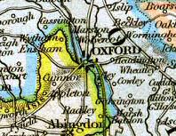
As an introduction to the site, you might look at some interesting items among the plates described above.
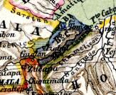
The detail to the left shows a Belgian colony
in Central America, bordering Guatemala, San Salvador and Honduras.
You can buy maps from the site. The images you can buy are large JPGs, showing the same plates as those described above, but at a higher resolution and with less compression.
|
Search for a place, battle, etc. in the maps here. | |
A list of the atlases here, in index order, so that those that have been here longest are shown first. A list of the most popular plates here, in order of popularity.
 A few enhanced maps,
using features of html and javascript to overlay maps for various effects.
A few enhanced maps,
using features of html and javascript to overlay maps for various effects.
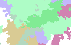
The example to the right shows a region of
Thuringia that requires six colours to colour it.